Friday, December 30, 2011

Arthur's Pass to Lake Coleridge - almost half way down the South Island

Past the Bealey on SH 73 heading for the Lagoon Saddle
Although it is not quite half way along the South Island section of the Te Araroa trail, reaching Arthur's Pass village was for me a great milestone, as it feels like I have completed a major part of the South Island journey. Also, after about 8 days tramping through the forests and rivers of the main divide, I was glad of a good shower and a comfortable sleep at the YHA. The weather was also on the improvement, and there is nothing like a bit of sun on your back to brighten up the adventure. This section of the trail moves away from the forest covered mountains of the west and into the drier tussock high country of the east. A lovely change of scenery and a great measurement of progress.

On reaching Lake Coleridge village, I had also now reach the Rakaia River and the first of two major safety hazards along this part of the trail. The Rakaia River is a mighty braided river system, very dangerous most of the time and far too dangerous for solo trampers to attempt to cross by myself. So to overcome this hazard, Lynda very kindly offered to bring the 4 wheel drive Nissan up to Lake Coleridge and deliver me around the other side (via the Rakaia gorge bridge), so that I could start the Hakatere track section and continue to move south.

Thursday, December 29, 2011

Crossing the main divide - Harper Pass

In historic times, the Harper Pass was the main pathway to the west coast for maori trading greenstone and later for the miners in the gold rush of 1864-65. It is one of my favourite South Island tramping areas, and this is my 4th crossing through this part of the southern alps.

A wet afternoon spent writing up my notes

Hurunui No 3 hut - built in 1939

I had a couple of days of wet weather as I tramped up past Lake Sumner and on over the Harper Pass. There are plenty of good huts though, so a good chance to rest and relax.


A good opportunity to cook up some more substantial meals - this one is my favourite bacon risotto

Travelling down the Taramakau River on the western side is always a bit tricky after heavy rain, but the weather cleared by the time I crossed over the pass, making the frequent river crossing quite easy. I spent some of my childhood living and playing in this valley, so it always feels a bit like coming home for me. And this is a magic part of the world. You can feel the wilderness all about you, as if you are the only person on the planet.

Wednesday, December 28, 2011

St Arnaud to Boyle River - with some minor road detours (day 97 to day 102)

 Although we had reasonably good weather through most of Richmond Forest Park, heavy rain in the Nelson Lakes National Park over the last two weeks, had taken out a number of bridges and damaged some of the tracks, but more frustrating for me, it had dumped more snow on the Waiau Pass. Even under normal spring conditions, the Waiau Pass is marginal for solo trampers in November and with the recent cold southerlies, the snow was just not melting fast enough (as an idea how cold it still was - Lake Angelus was still frozen over, not very common for November). So, on the advice of DOC and local experts, I decided to detour down the Rainbow Valley, through Sedgemere, over the Malling Pass and join the Waiau River (and the Te Araroa trail again) just downstream from the Waiau Pass.

Walking through Molesworth Station
 

This proved to be a splendid alternative. It was a bit longer (just over 129 km in six days) but it gave me the opportunity to travel through both the Rainbow Station and Molesworth Stations, and see new parts of the South Island backcountry that I had not seen before. It was also quite refreshing (dare I say) to walk on flats roads again, even if they were only metal roads. There was next to no traffic at all. 

Lake Sledgemere after a clearing storm
I loved the areas around Lake Sedgemere and Lake Tennyson, and the Island Saddle at 1347 m, is the highest public road in New Zealand. It's big country, lots of wide open space and beautful vistas.

Tuesday, December 13, 2011

Mt Richmond Forest Park - a challenge for all trampers

My son Ryan joined me for this part of the tramp through the Richmond Forest Park.This section of the Te Araroa trail starts at the delightful picnic spot of Pelorous Bridge. The track is well known for its' beautiful tall native forest, mainly red beech, as it runs alongside the crystal clear Pelorous River, so for the first few days it is long but easy walking. The weather was great and although we were carrying heavy packs (10 days food), we made good progress.

However, as we moved further south and up onto the Richmond Ranges proper, the alpine section as they call it, the tramping got harder and the days longer. We often climbed up the 1,000 meters in the morning, only to descend 600 meters in the afternoon.
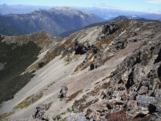
The weather was kind to us and we needed it to be, as we negotiate the high exposed mountain ridges and the rocky crags, that we often had to work our way around. But the scenery was just bearth-taking, mountains as far as the eye could see. We felt on top of the world and it's days like this that you know why you love tramping so much. Just wish it wasn't all on the same day.


These mountains are hard work. It is certainly "full-on" tramping and you need to have a good sence of adventure, to get the best out of it and enjoy the experience.