Friday, December 30, 2011

Arthur's Pass to Lake Coleridge - almost half way down the South Island

Past the Bealey on SH 73 heading for the Lagoon Saddle
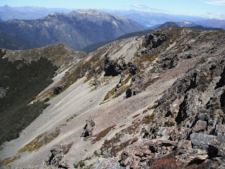
Although it is not quite half way along the South Island section of the Te Araroa trail, reaching Arthur's Pass village was for me a great milestone, as it feels like I have completed a major part of the South Island journey. Also, after about 8 days tramping through the forests and rivers of the main divide, I was glad of a good shower and a comfortable sleep at the YHA. The weather was also on the improvement, and there is nothing like a bit of sun on your back to brighten up the adventure. This section of the trail moves away from the forest covered mountains of the west and into the drier tussock high country of the east. A lovely change of scenery and a great measurement of progress.

On reaching Lake Coleridge village, I had also now reach the Rakaia River and the first of two major safety hazards along this part of the trail. The Rakaia River is a mighty braided river system, very dangerous most of the time and far too dangerous for solo trampers to attempt to cross by myself. So to overcome this hazard, Lynda very kindly offered to bring the 4 wheel drive Nissan up to Lake Coleridge and deliver me around the other side (via the Rakaia gorge bridge), so that I could start the Hakatere track section and continue to move south.

Thursday, December 29, 2011

Crossing the main divide - Harper Pass

In historic times, the Harper Pass was the main pathway to the west coast for maori trading greenstone and later for the miners in the gold rush of 1864-65. It is one of my favourite South Island tramping areas, and this is my 4th crossing through this part of the southern alps.

A wet afternoon spent writing up my notes

Hurunui No 3 hut - built in 1939

I had a couple of days of wet weather as I tramped up past Lake Sumner and on over the Harper Pass. There are plenty of good huts though, so a good chance to rest and relax.


A good opportunity to cook up some more substantial meals - this one is my favourite bacon risotto

Travelling down the Taramakau River on the western side is always a bit tricky after heavy rain, but the weather cleared by the time I crossed over the pass, making the frequent river crossing quite easy. I spent some of my childhood living and playing in this valley, so it always feels a bit like coming home for me. And this is a magic part of the world. You can feel the wilderness all about you, as if you are the only person on the planet.

Wednesday, December 28, 2011

St Arnaud to Boyle River - with some minor road detours (day 97 to day 102)

 Although we had reasonably good weather through most of Richmond Forest Park, heavy rain in the Nelson Lakes National Park over the last two weeks, had taken out a number of bridges and damaged some of the tracks, but more frustrating for me, it had dumped more snow on the Waiau Pass. Even under normal spring conditions, the Waiau Pass is marginal for solo trampers in November and with the recent cold southerlies, the snow was just not melting fast enough (as an idea how cold it still was - Lake Angelus was still frozen over, not very common for November). So, on the advice of DOC and local experts, I decided to detour down the Rainbow Valley, through Sedgemere, over the Malling Pass and join the Waiau River (and the Te Araroa trail again) just downstream from the Waiau Pass.

Walking through Molesworth Station
 

This proved to be a splendid alternative. It was a bit longer (just over 129 km in six days) but it gave me the opportunity to travel through both the Rainbow Station and Molesworth Stations, and see new parts of the South Island backcountry that I had not seen before. It was also quite refreshing (dare I say) to walk on flats roads again, even if they were only metal roads. There was next to no traffic at all. 

Lake Sledgemere after a clearing storm
I loved the areas around Lake Sedgemere and Lake Tennyson, and the Island Saddle at 1347 m, is the highest public road in New Zealand. It's big country, lots of wide open space and beautful vistas.

Tuesday, December 13, 2011

Mt Richmond Forest Park - a challenge for all trampers

My son Ryan joined me for this part of the tramp through the Richmond Forest Park.This section of the Te Araroa trail starts at the delightful picnic spot of Pelorous Bridge. The track is well known for its' beautiful tall native forest, mainly red beech, as it runs alongside the crystal clear Pelorous River, so for the first few days it is long but easy walking. The weather was great and although we were carrying heavy packs (10 days food), we made good progress.

However, as we moved further south and up onto the Richmond Ranges proper, the alpine section as they call it, the tramping got harder and the days longer. We often climbed up the 1,000 meters in the morning, only to descend 600 meters in the afternoon.
The weather was kind to us and we needed it to be, as we negotiate the high exposed mountain ridges and the rocky crags, that we often had to work our way around. But the scenery was just bearth-taking, mountains as far as the eye could see. We felt on top of the world and it's days like this that you know why you love tramping so much. Just wish it wasn't all on the same day.


These mountains are hard work. It is certainly "full-on" tramping and you need to have a good sence of adventure, to get the best out of it and enjoy the experience. 

Wednesday, November 16, 2011

South Island - mountains and rivers lay before me.


My first look at the SI for almost 3 months, as the Cook Strait ferry enters Tory channel. Most of my journey from now on will be in the mountains, so it could be a while before I post on this blog again. But watch this space.


Completed the North Island section of the Te Araroa trail

Wet morning at the Cable Car
Te Araroa sign at Island Bay
On a rainy Wellington afternoon and after 87 days, I have completed the NI section of Te Araroa trail. Great to reach this milestone and the satisfaction that I'm now half way through my 3,000 km journey down the length of New Zealand.

Monday, November 14, 2011

It's full on tramping - as we tackle the Tararua's

 I'd heard a lot about tramping in the Tararua's, some of it good, but some of it scary. But after endless days of road walking, I was looking forward to the challenge of some "real tramping". My daughter Rebecca has joined me on this section, so it's good to have her company and to share the experience.

Early morning start on day one
 
The weather improves on day two


Checking out the next ridge - plenty of choices
 Tramping in the Tararua's is certainly hard work, but the scenery is rewarding. The tracks are steep, both up and down, the huts are a reasonable distance apart, but it is the weather that is your greatest enemy. On fine days it is challenging, yet satisfying, but on cold, wet days, life in the Tararua's is just dan right miserable. We had a mixed bunch, 50/50 wet and fine, so we enjoyed the good days, and longed to be somewhere else on the other days. But the huts were good, especially Nichol's Hut, with it's great little pot-bellied stove. So, all in all, a great tramping experience. I'll be back.

Wednesday, November 2, 2011

Road walking to Levin.

Walking SH57 just north of Shannon
Some friends join me for my roadside lunch
"Back on the road again", as the song goes, but not far to go now. So with a pack full of new supplies and after plenty of road walking from Whanganui (via Bulls, Feilding and Palmerston North), although I must say, mainly on lovely backcountry roads, I have now reached Levin. While in Palmerston North, I stayed with some alpaca friends, Lars and Heather Olsen, and it was great to sleep in a real bed and live in a real house after weeks of camping. So thanks for break and the chance to feel almost normal again.
I am now waiting in Levin for my daughter, Rebecca, to join me for the tramp through the Tararua Ranges. It's lovely to have family members join me on some of the sections of the Te Araroa trail, it makes it really special and adds to the whole experience. The weather has been a bit dodgy lately, so fingers crossed for the Taraua's.
Wellington here we come!!!!!

Thursday, October 27, 2011

Whanganui River Journey - Day 60 to Day 66


The journey down the Whanganui river was a great adventure. Lynda has joined me for this 6 day (176 km) canoe trip, from Whakahoro to Whanganui city. We stayed in DOC huts most of the way, John Coull, Tieke Kainga (which is also a Marae), Downes Hut and then tented at other campsites down the river. We had a little bit of rain on the first and last days, but otherwise the weather was great. It was a magic experience, canoing quietly down the river through the gorges and fern covered cliffs. Although, I think the highlight had to be watching the RWC final at the "Bridge to Nowhere Lodge", way out in the middle of the bush, the only house on the river for miles, on sky TV, powered by a generator. The owner came and collected over 29 of us from the John Coull hut, in his jet boat, to avoid the danger of some of us attempting to canoe accross the river, after a few drinks. What a night. Go the AB's.

A canoe trip like this was a welcome break from carrying a backpack, first it is a great relief not carrying the wieght and then there is the added advantage that you can carry so much more food, and fresh food at that. Bacon and eggs for breakfast and steak for dinner. We also took a cask of wine, with cheese and crackers and lots of lovely dips. Lynda's brother Brian and his friend Pat also joined us for the first two days, so it was a bit of a family adventure. We had 4 large barrels strapped into our canoe and they were full. Every night we stopped, we had to lug these barrels up steep and slippery paths to the hut or campsites. Not sure how I'm going to adjust back to dehydrated rations again, as I head down the coast and back on the road again. Now over 1,300 km since I started in August and less than two weeks away from Wellington.

Tongariro National Park - a complete round trip taking me past the 1,000 km mark

The Te Araroa trail includes the Tongariro Crossing, but having saved a bit of time by by-passing the 42 travrese, I decided to make good use of the extra days and really have a good crack at these wonderful volcanic peaks. With a full pack of food or at least enough for 9 days, I set off to complete both the "around the moutain" and "northern circuit" tramping tracks. A combined distance of just over 100 km, starting and finishing at Ohakune. Although it is already late spring (20 Oct), there is still plenty of snow, as the track circles the mountains at about the 1,400 m mark. In fact as the weather was so changable, I got a mixture of sun and snow showers most days. This made for an interesting time as I went over the Tongariro Crossing, the highest (1860 m) and most northerly part of my route. I climbed up from Oturere hut in bright morning sun, although through heavy snow and onto the souuth basin. I got time for just one photo only (the one I posted on Facebook), before low cloud and freezing fog rolled in. Complete "white out" in a matter of only a few minutes. There were other people on the mountain, mainly tourists, many of them scurring to get down to lower levels and almost all travelling in the other direction passed me. I decided to press on, as I felt it was safer following other peoples footprints and heading into the wind, than against it. The main problem however, was the wind got stronger at the top of Red Crater, not only was it throwing me and my pack around, it was also covering up the footprints in the snow, that I was using as my guide to get from one snow pole to the other. Then I ran out of snow poles, some of them were missing, good on you DOC, has anybody checked the snow poles recently. Not a good look I thought, as I stood there staring out into the whilteness. I was just about to get out my GPS and apply a bit of modern technology, when I heard voices coming towards me. It was a local tour guide trying to get his party off the mountain, while at the same time gathering up other lost soles on the way. This party made a clear track for me to follow and in another 20 minutes or so I was down to clearer conditions and best of all, out of the wind. I hear later from DOC staff, that search and rescue had to pull 5 tourists off the TC that day, who had wondered off the track and got lost. The rest of my trip around the moutain was uneventful in comparison.

Old huts and wild pigs

Pureora Forest Park and the land of tall trees


After making my way down the Te Araroa trail, through Te Kuiti and Benneydale, I set about preparing myself for the 3 or 4 days of forest walking trough the Rureora Forest along the Hauhungaroa track. This track follows the Hauhungaroa moutain range along the western side of Lake Taupo. This is beautiful forest, with some of the tallest native trees in the country. I saw NZ's tallest Totara, amongst others. Also, the bird life is fantastic. Lots of Kaka flying about, feeding in the trees high above and at night I heard plenty of kiwi calling in the thick bush. And to my delight, I saw several family groups of the lovely little "Whitehead" or the north island bush canary. This was a really first for me.

Unfortunately, on the 3rd day into my bush trek, I ran into some really bad weather and after heavy rain had effected rivers and streams, I decided to bail out and took a side track which lead me down to the highway alongside Lake Taupo. From the I walked to Turangi and on to Tongariro NP.

Wednesday, October 5, 2011

Mt Pirongia - high in the clouds on day 43

After a few days rest and a chance to catch up with old friends, at the Alpaca Expo, I have now resumed my journey south from Hamilton. First stop was Mt Pirongia. Climbing the 986 m high Mt Pirongia was a challange, especially with a full pack, after I had loaded up several more kgs of food from the Bin Inn in Hamilton. It took just on 6 hours to reach the summit and then another 30 minutes to progress along the ridge to the DOC hut, perched in the forest overlooking the valley below. And what a beautiful place, thick cloud forest and stunning rock outcrops. I had the hut to myself and the peace and quiet, that comes with such a place. Photos to come once I get to a camera store.

Saturday, September 24, 2011

Following the Waikato River to Huntly

It took two or three big days to work my way through South Auckland and back into the country again. Road walking is just part of life when you want to make progress and even walking down the edge of SH1 is worth it just to get back on the nature trail. I really loved the walks alongside the Waikato River, where the track follows the stop banks. I never realised just how big the Waikato river this really is, like a lazy oneway lake, just slowly moving down to the sea. Great wildlife, waterfowl everywhere and the size of those Koi Karp (fish) feeding in the shallows was amazing. I made a small detour to stay with friends (Chris and Laurie Wilson) in Pukekoe and then on day 34, I arrived in Huntly to stay with Mark and Mary-Ann Pruden. Another day off, a chance to do the washing and best of all, to sleep in a real bed.

The big day south through Devonport and accross Auckland

This was a big day for me as I travelled over 40 km through the big smoke. It was a great feeling to catch the ferry in Devonport and land in downtown Auckland, and for those of you who have been worrying that I have been missing out on events in the rugby world cup, then I thought this photo taken at party central on Queen's Warf, shows that I'm not. The Auckland city section takes in many of the parks and reserves in the city as it crosses the 14 km coast to coast section. I loved this section, especially Cornwall Park and one tree hill. The day ended up at Ambury Regional Farm Park, very close to the airport, where I was able to camp for the night.

The coast from Orewa through Caster Bay to Takapuna

From Puhoi the Te Araroa trail moves out to the coast again passing the lovely little beach settlement of Waiwera and then over the hill to Orewa. Now I have reached the outskirts of Auckland. I start to feel excited about the prospect of moving south and out of northland that has been my home for the last 4 weeks. Orewa has a great little shopping area and a good chance to catch up on my email and blog. I spent two nights at the camping ground and waited out the last of the southerly showers, before moving further down the coast to Takapuna.

Sunday, September 18, 2011

Now past the 500 km mark, as I head south of Workworth

Back inland again, as I tramped over the forest covered hills south of Pakiri and down through the farmland valleys to Matakana and Workworth. Now past the 500 km mark, yeah !!!, since leaving Cape Reinga over 3 weeks ago. A great milestone behind me, now only 2,500 km to go. Stopped at a lovely little town of Puhoi, with historic church and pub. So I took a photo of the church and then visited to pub. Well, it was Sat afternoon and I had to go past the church to get to the pub. There is a photo of the inside of the pub, but that's on Facebook. Not a lot of accomodation options, but the local's were great and invited me to camp in the local reserve, if I could find some dry ground. So I set up camp in the day shelter. Nice and dry in there.

More sand and surf, as I head south and back to the beach again

Now day number 24 and the weather is kind to me again, as I head down the long 15 km beach walk to Pakiri. I have got to like beach walking, plenty of peace and quiet, no cars and not a lot to trip over if you don't look where you are going. And it's flat. The bird life is great to watch, as many of the sea birds have started nesting, so I keep well away from the dunes. Don't see another person most of the day, only when I head inland or get to a camping ground. When the sun is out and the walking is flat, then live is easy. If only it was all like this.

Waipu Cove - back on the coast again

Big thunderstrom in Whangarei on Sunday, so I took the day off, did some washing and watched the rugby. Staying in the YHA. But the weather cleared on Monday and I headed back out towards the coast. It was a long road walk from Whanagrei to Waipu Cove (40+ km) and that traffic on SH1 is a shocker, but it was good to be out of the city and back towards the sea and sand again. Like most of the seaside camp grounds, Waipu Cove is empty this time of year and a great place to re-charge the batteries after a long road walk. Back into the hills tomorrow.

Thursday, September 8, 2011

Whangarei coastal track

More beautiful sandy beaches and more sunshine. What a life. Or it would be, if I didn't have to carry this heavy pack, climb up and down steep hills (why don't track makers follow the contours like most animals do) and of course sleep on the ground every night. Just kidding, it's really such stunning coastline, that it would be hard not to enjoy such a beautiful walk.
Day 17 saw me leaving the lovely little camp ground at Whananaki North, where the lady was so impressed at my efforts so far on the Te Araroa trail that she gave me a big discount and even washed some of my cloths for me. Maybe she was trying to tell me something. There is a great Te Araroa graphic sign on the beach at Whananaki, showing the Onekainga track that I had come down the day before and it tells me the I ahve already reached 316 km from Cape Reinga. Starting to crank up the km now.
The coastal track follows up and down passed more beautiful coves and bays, Sandy Bay, Woollys Bay, Matapouri Bay and must be one of the great highlights of this walk. Through to Ngunguru for the next section, but no where to camp, so doubled back to Tutukaka and a flash new camping ground, And those lovely hot showers again. The manager at this camping ground was also impressed, he even gave me a beer for my efforts but not my washing. Well, I don't expect you can have it all.

Back to the Coastline

I stayed overnight in a beautiful little camping ground at Oakura Bay and after 3 days in the bush it was really good to get a shower and have the use of a camp kitchen. Oh, how lovely to have access to hot water and multiple cups of tea, without having to light up my little stove. The camp is right on the waters edge, very pretty and I was greeted with yet another crystal clear morning. I can't believe my luck with the weather, one great day after another.
The walk down the coast again passes many sandy bays before turning inland again for another forset tramp along high ridges and deep valleys. Beautiful forset, very lush, more like tropical jungle really. Lots of vines and groves of Nikau palms. This time it is the Morepork (more DOC land) track and once again I camped high on the ridgeline (but this time I remembered to fill up extra water bottles). There has been some concern about the track marking but I had no trouble picking up the right trail.

Russell Forest

It's Day 12 and I'm on the move again. Lovely coastal walk from Paihia around to Opua, where I caught the car ferry to the east coast. Passed lots of small bays, all with clusters of holiday homes, as the Te Araroa trail makes it's way south again. The weather is still beautiful, short sleeves all day and only need to grab my jacket after dark. Camped the first night just inside the Russell Forest, up on the ridgeline. It was really lovely with the setting sun fading through canopy, followed not long later by the rising moon. The local wildlife (many Moreporks) seems to be recoverying, now that DOC is active in predator control, even heard a couple of kiwi calling down in the valley.

I carried on along the ridgeline on the second day but then ran out of water. I'm carrying 2 litres, but by the time you cook an evening meal and then a chuppa for breakfast, there's not much left. So it was about 2 pm in the afternoon when I reached the first main water source for the day, a large clear stream close to a DOC camping shelter. I made this my second night in the forest, sleeping on a platform in the DOC shelter. That was fun, with the possums visiting all night and me waving my walking poles at them to keep them off my food. I think we came to an understanding sometime after midnight and they left me alone.

Thursday, September 1, 2011

Now in Paihia and ready for a break

I have arrived in Paihia and I'm ready for a break. My feet and legs are good, no blisters (yet) but after a number of days road walking the soles of my feet are sore. So it's a day off for me, as I hit the highlights of Paihia, which really means a real bed at the Paihia YHA. Weather is still good but not as warm as last week, great in the sun but the wind is cool up on the ridges. Passed through Kerikeri yesterday, by the old stone store, beautiful old building. Will re-supply here as I get ready to move south again.

Friday, August 26, 2011

Completed the first section - to Ahipara

Four days walking along the beach is a great intro to tramping the lenght of NZ. The weather has been wonderful, shorts and T shirt conditions the whole way down and I even had a swim in the surf on the Thursday. Got sun burnt yesterday, as I packed in 34 km to reach the holiday camp and a warm shower. Some great campsites at Twilight Beach and again at the Bluffs. and plenty of freash air. Good stuff. More to come as soon as I get the time.

Day one on Te Araroa - Tuesday - Cape Reinga

Well what a great adventure, starting the Te Araroa trail at long last. And it was a beautiful day, with the sun streaming down between the clouds. Started quite late so only made 6 km the first day, camping above the cliffs near Twilight Bay. Photos to follow once I get to big town.

Monday, August 15, 2011

More meals being prepared for my Te Araroa journey


Vacuum packing machine in action

Pasta broken down into meal lots


For multi day tramps, like the Te Araroa trail, I find that by using a small vacuum packing machine, I am able to both reduce the size (and bulk) of the meals and improve the shelf life. By sealing the meals in airtight conditions they often last for weeks without deteriorating and it reduces the chance of moister getting in to things like milk powder. I now have over 357 separate meals ready to use on my Te Araroa journey.

Friday, August 12, 2011

Food packing well under way - dehydrated and vacuum packed, ready for use.

For the 5 month journey I will need over 450 separate meals, plus heaps of snacks and nibbles. Some of this can be purchased in the many small towns I will pass through walking the length of NZ, but most will need to be prepared in advance and re-located in food drops up and down the country. To date I have dehydrated, measured and weighed about 245 separate meals, most of which have been vacuum packed to preserve their shelf life.

Wednesday, July 20, 2011

Planning for Te Araroa

I am now well into the planning stages for my 5 month walk the length of New Zealand, along the 3,000 km Te Araroa trail and I have been really suprised just how much planning is needed. When I first came up with this project, I just thought, oh well, not much different to any other multi day tramp I've been on - just a bit longer, that's all. But no, each step takes a lot more work and planning.
Food prep is not a big concern for me, as food planning is what I really do best, so this has been really fun. Although re-supply in some of the more remote areas of the NI looks interesting and I am having to prepare food drops on some of the longer sections of the SI. I have now started buying food in bulk and breaking it down into meal size portions. It's going to make an interesting photo when it's all put together.